
Thank you for supporting this site ❤️
Make a donation
Make a donation
Monte Igno topographic map
Click on the map to display elevation.
Thank you for supporting this site ❤️
Make a donation
Make a donation
About this map
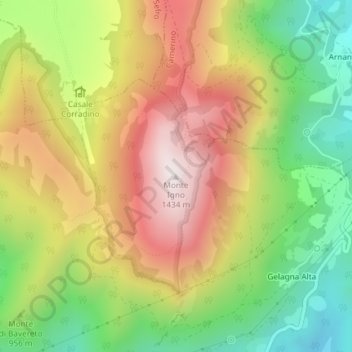
Name: Monte Igno topographic map, elevation, terrain.
Location: Monte Igno, Serravalle di Chienti, Macerata, Italia (43.09291 12.98916 43.09301 12.98926)
Average elevation: 983 m
Minimum elevation: 568 m
Maximum elevation: 1,429 m
Thank you for supporting this site ❤️
Make a donation
Make a donation