
Thank you for supporting this site ❤️
Make a donation
Make a donation
Pasir Kembang topographic map
Click on the map to display elevation.
Thank you for supporting this site ❤️
Make a donation
Make a donation
About this map
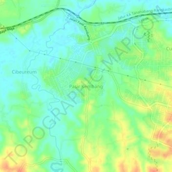
Name: Pasir Kembang topographic map, elevation, terrain.
Location: Pasir Kembang, Lebak, Java, Indonesia (-6.36722 106.34332 -6.32722 106.38332)
Average elevation: 42 m
Minimum elevation: 25 m
Maximum elevation: 70 m
Thank you for supporting this site ❤️
Make a donation
Make a donation
Other topographic maps
Click on a map to view its topography, its elevation and its terrain.