
Thank you for supporting this site ❤️
Make a donation
Make a donation
Comblain-la-Tour topographic map
Click on the map to display elevation.
Thank you for supporting this site ❤️
Make a donation
Make a donation
About this map
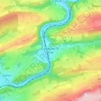
Name: Comblain-la-Tour topographic map, elevation, terrain.
Location: Comblain-la-Tour, Hamoir, Huy, Liège, Wallonie, 4180, Belgique (50.43531 5.54995 50.47531 5.58995)
Average elevation: 191 m
Minimum elevation: 100 m
Maximum elevation: 319 m
Thank you for supporting this site ❤️
Make a donation
Make a donation
Other topographic maps
Click on a map to view its topography, its elevation and its terrain.
Thank you for supporting this site ❤️
Make a donation
Make a donation