
Thank you for supporting this site ❤️
Make a donation
Make a donation
Saint Cloud topographic map
Click on the map to display elevation.
Thank you for supporting this site ❤️
Make a donation
Make a donation
About this map
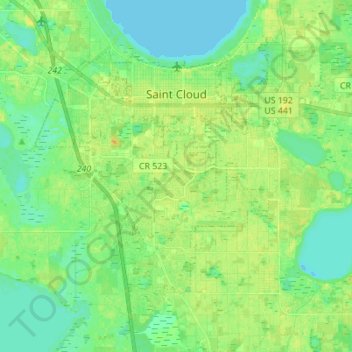
Name: Saint Cloud topographic map, elevation, terrain.
Location: Saint Cloud, Osceola County, Florida, United States (28.17356 -81.33948 28.26930 -81.20169)
Average elevation: 21 m
Minimum elevation: 12 m
Maximum elevation: 32 m
Thank you for supporting this site ❤️
Make a donation
Make a donation
Other topographic maps
Click on a map to view its topography, its elevation and its terrain.