

Vérignon topographic map
Click on the map to display elevation.
Vérignon
The plain is also an important findspot for prehistoric fossils, with most of those found being conserved fossils in the château at Vérignon, not open to the public. According to Raoul Bérenguier, the Blacas seigneurs of Aups installed themselves in Vérignon around the year 1000 and constructed their castle on a rocky outcrop in the town. It had an encircling wall, rectangular living quarters in the north corner, a private chapel of the Assumption for the Blacas (with their family vault under its altar), and a barbican round its south gate. However, this castle proved too constricted, uncomfortable and small, and was abandoned at the start of the 18th century, with the Blacas building a new, unfortified château, which remained in their hands until 1947. It is rectangular in plan, with two levels of overhanging elevations, an attic-storey, and corner towers. Two short wings project out from and frame the main building. The castle stands up in the middle of a magnificent park.
About this map
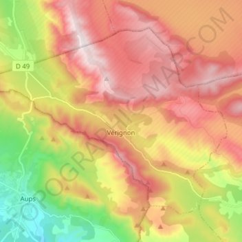
Name: Vérignon topographic map, elevation, terrain.
Average elevation: 824 m
Minimum elevation: 452 m
Maximum elevation: 1,143 m
Other topographic maps
Click on a map to view its topography, its elevation and its terrain.

Berne
France > Provence-Alpes-Côte d'Azur > Var > Saint-Maximin-la-Sainte-Baume
Average elevation: 512 m

Plage du Canon
France > Provence-Alpes-Côte d'Azur > Var > Saint-Mandrier-sur-Mer
Average elevation: 18 m
Puget-sur-Argens
France > Provence-Alpes-Côte d'Azur > Var > Puget-sur-Argens > Puget-sur-Argens
Average elevation: 20 m
Grotte des Tuves
France > Provence-Alpes-Côte d'Azur > Var > Saint-Cézaire-sur-Siagne
Average elevation: 362 m