
Make a donation
Querétaro topographic map
Click on the map to display elevation.
Make a donation
Querétaro
Three of Mexico’s geographic zones cover parts of the state. The Mesa del Centro is in the center-west of the state, and mostly consists of small mesas with an average altitude of 2,000 meters (6,562 feet) above sea level (ASL). A few elevations reach over 3,000 meters (9,843 feet). The Sierra Madre Oriental occupies the northeast of the state and includes the cities of Huasteca area. The topography of this area is rugged, with long mountain chains and narrow valleys. Elevations here range between 900 m (2,953 ft) and 3,000 m (9,843 ft) m ASL. The Trans-Mexican Volcanic Belt occupies about half of the state in the center and south. The area is mostly volcanic rock with peaks and mesas between 200 m (656 ft) and 3,000 m (9,843 ft) and valleys between 1,800 m (5,906 ft) and 1,900 m (6,234 ft) ASL.
Make a donation
About this map
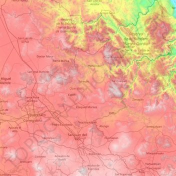
Name: Querétaro topographic map, elevation, terrain.
Location: Querétaro, Mexico (20.01502 -100.59654 21.67001 -99.04308)
Average elevation: 1,881 m
Minimum elevation: 50 m
Maximum elevation: 3,257 m
Make a donation
Other topographic maps
Click on a map to view its topography, its elevation and its terrain.
Ciudad Victoria
Mexico > Tamaulipas > Victoria
Ciudad Victoria has a climate on the border of humid subtropical (Köppen Cfa/Cwa) and hot semi-arid (BSh). Its weather is characterised by short warm winters and long hot to sweltering summers. Temperatures rarely drop below 0 °C (32 °F) — the lowest recorded temperature was −6 °C (21.2 °F) and the…
Average elevation: 518 m
Texcoco de Mora
Mexico > State of Mexico > Texcoco
Tescoco lies about 25 km east of the centre of Mexico City. Major elevations in the municipality include the Tlaloc Mountain (4,500 meters) the Tetzcutzinco, Moyotepec and Tecuachacho. Most elevations are named after the major community to be found on them. There are also a number of small canyons. Part of the…
Average elevation: 2,262 m
Make a donation
Paseo al Monte (Camino a la Boquilla)
Mexico > Zacatecas > Moyahua de Estrada > Moyahua de Estrada
Average elevation: 1,224 m
Make a donation
Make a donation
Make a donation
Chihuahua
Mexico > Chihuahua > Municipio de Chihuahua
Chihuahua lies on the western side of the Chihuahuan Desert ecoregion and as such has a semiarid climate (Köppen climate classification BSh). However, it is not as hot as most of the lower elevated portions of the desert to the east owing to an altitude of almost 1,500 metres (4,900 feet) above sea level.
Average elevation: 1,555 m
Make a donation
Make a donation
Hecelchakán
Mexico > Campeche > Hecelchakán
It is at an altitude of 10 m above sea level.
Average elevation: 34 m
Piedras Negras
Mexico > Coahuila > Municipio de Piedras Negras > Piedras Negras
Average elevation: 256 m
Make a donation
Make a donation