
Make a donation
Hillsborough County topographic map
Click on the map to display elevation.
Make a donation
Hillsborough County
Hillsborough County, located in west-central Florida, features a predominantly flat terrain with gentle undulations. The county's landscape is characterized by low-lying coastal plains that rise gradually from the shores of Tampa Bay, with elevations typically ranging from 16 to 66 feet (5 to 20 meters) above sea level. The highest points in the vicinity reach approximately 164 feet (50 meters). This relatively flat topography is interspersed with numerous water bodies, including the expansive Tampa Bay to the west and the Hillsborough River that meanders through the area, contributing to its lush vegetation and diverse ecosystems. The surrounding areas often feature wetlands and marshlands, particularly as one moves toward the coast, creating a rich environment for both wildlife and recreational activities.
Make a donation
About this map
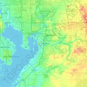
Name: Hillsborough County topographic map, elevation, terrain.
Location: Hillsborough County, Florida, United States (27.57055 -82.82367 28.17338 -82.05401)
Average elevation: 20 m
Minimum elevation: -2 m
Maximum elevation: 90 m
Make a donation
Other topographic maps
Click on a map to view its topography, its elevation and its terrain.
Make a donation
Make a donation
Make a donation
Make a donation
Lealman
United States > Florida > Pinellas County
Lealman is located at 27°49′10″N 82°41′4″W / 27.81944°N 82.68444°W / 27.81944; -82.68444 (27.8197, -82.6846). The community is bordered by the city of Pinellas Park to the north, St. Petersburg to the east and south, and by the town of West Lealman to the west. The elevation is 49 feet (15…
Average elevation: 13 m
Make a donation
Make a donation
Make a donation