
Thank you for supporting this site ❤️
Make a donation
Make a donation
Cangas de Onís topographic map
Click on the map to display elevation.
Thank you for supporting this site ❤️
Make a donation
Make a donation
About this map
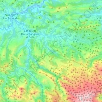
Name: Cangas de Onís topographic map, elevation, terrain.
Location: Cangas de Onís, Asturias, Spain (43.20295 -5.18461 43.42453 -4.94153)
Average elevation: 591 m
Minimum elevation: 8 m
Maximum elevation: 2,440 m
Thank you for supporting this site ❤️
Make a donation
Make a donation
Other topographic maps
Click on a map to view its topography, its elevation and its terrain.