
Xining topographic map
Interactive map
Click on the map to display elevation.
About this map
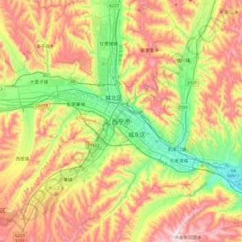
Name: Xining topographic map, elevation, terrain.
Location: Xining, 城中区, 西宁市, Qinghai, 810000, China (36.45733 101.61620 36.77733 101.93620)
Average elevation: 2,505 m
Minimum elevation: 2,140 m
Maximum elevation: 2,969 m
Other topographic maps
Click on a map to view its topography, its elevation and its terrain.
Qinghai-See
Qinghai-See, གསེར་ཆེན་རྫོང 共和县, 海南州, Qinghai, China
Average elevation: 3,332 m
Hoh Xil Shan
China > Qinghai > ཟོ་སྐྱ 索加乡
Hoh Xil Shan, ཟོ་སྐྱ 索加乡, འབྲི་སྟོད་རྫོང་治多县, 玉树州, Qinghai, China
Average elevation: 5,203 m
Bayan-Har-Gebirge
Bayan-Har-Gebirge, 玛多县, རྨ་སྟོད་རྫོང་ 玛多县, 果洛州, Qinghai, China
Average elevation: 4,304 m