
Thank you for supporting this site ❤️
Make a donation
Make a donation
Thrikkodithanam topographic map
Click on the map to display elevation.
Thank you for supporting this site ❤️
Make a donation
Make a donation
About this map
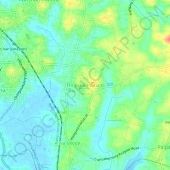
Name: Thrikkodithanam topographic map, elevation, terrain.
Average elevation: 16 m
Minimum elevation: -1 m
Maximum elevation: 46 m
Thank you for supporting this site ❤️
Make a donation
Make a donation
Other topographic maps
Click on a map to view its topography, its elevation and its terrain.
Thank you for supporting this site ❤️
Make a donation
Make a donation
Sri Subramanya swami Kshethra Kulam, Perunna
India > Kerala > Changanassery > Changanassery
Average elevation: 6 m