
Thank you for supporting this site ❤️
Make a donation
Make a donation
Radda in Chianti topographic map
Click on the map to display elevation.
Thank you for supporting this site ❤️
Make a donation
Make a donation
About this map
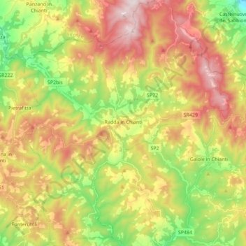
Name: Radda in Chianti topographic map, elevation, terrain.
Location: Radda in Chianti, Siena, Tuscany, 53017, Italy (43.42423 11.29599 43.54846 11.44910)
Average elevation: 484 m
Minimum elevation: 143 m
Maximum elevation: 863 m
Thank you for supporting this site ❤️
Make a donation
Make a donation
Other topographic maps
Click on a map to view its topography, its elevation and its terrain.