
Thank you for supporting this site ❤️
Make a donation
Make a donation
Anadarko topographic map
Click on the map to display elevation.
Thank you for supporting this site ❤️
Make a donation
Make a donation
About this map
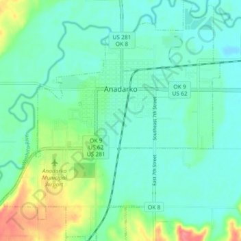
Name: Anadarko topographic map, elevation, terrain.
Location: Anadarko, Caddo County, Oklahoma, 73005, United States (35.03484 -98.27944 35.09436 -98.21401)
Average elevation: 369 m
Minimum elevation: 351 m
Maximum elevation: 420 m
Thank you for supporting this site ❤️
Make a donation
Make a donation
Other topographic maps
Click on a map to view its topography, its elevation and its terrain.
Red Rock Canyon Adventure Park
United States > Oklahoma > Caddo County > Hinton
Average elevation: 492 m
Thank you for supporting this site ❤️
Make a donation
Make a donation