
Thank you for supporting this site ❤️
Make a donation
Make a donation
East Sparta topographic map
Click on the map to display elevation.
Thank you for supporting this site ❤️
Make a donation
Make a donation
About this map
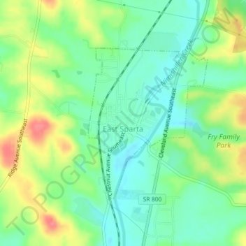
Name: East Sparta topographic map, elevation, terrain.
Location: East Sparta, Stark County, Ohio, United States (40.65962 -81.35991 40.67614 -81.34260)
Average elevation: 310 m
Minimum elevation: 283 m
Maximum elevation: 356 m
Thank you for supporting this site ❤️
Make a donation
Make a donation
Other topographic maps
Click on a map to view its topography, its elevation and its terrain.