
Thank you for supporting this site ❤️
Make a donation
Make a donation
Meung District topographic map
Click on the map to display elevation.
Thank you for supporting this site ❤️
Make a donation
Make a donation
About this map
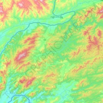
Name: Meung District topographic map, elevation, terrain.
Location: Meung District, Bokeo Province, Laos (20.47525 100.19188 20.84448 100.84399)
Average elevation: 714 m
Minimum elevation: 347 m
Maximum elevation: 1,767 m
Thank you for supporting this site ❤️
Make a donation
Make a donation
Other topographic maps
Click on a map to view its topography, its elevation and its terrain.