Mukkam topographic map
Interactive map
Click on the map to display elevation.
About this map
![Mukkam topographic map, elevation, terrain](/pub/maps/node/wh3l/274xj33l/thumbnail.jpg)
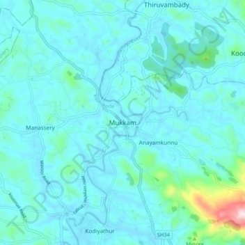
Name: Mukkam topographic map, elevation, terrain.
Location: Mukkam, Kozhikode, Kozhikode district, Kerala, 673602, India (11.28248 75.95488 11.36248 76.03488)
Average elevation: 50 m
Minimum elevation: 4 m
Maximum elevation: 433 m
Other topographic maps
Click on a map to view its topography, its elevation and its terrain.
![Parambil Bazar topographic map, elevation, terrain](/pub/maps/node/hrdn/18vzmf3/icon.jpg)
Parambil Bazar
Parambil Bazar, Kozhikode, Kozhikode District, Kerala, 673012, India
Average elevation: 25 m
![Vellimadukunnu topographic map, elevation, terrain](/pub/maps/relation/skl/grk1gt/icon.jpg)
Vellimadukunnu
India > Kerala > Kozhikode > Kozhikode
Vellimadukunnu, Kozhikode, Kozhikode District, Kerala, India
Average elevation: 27 m
![Kodampuzha topographic map, elevation, terrain](/pub/maps/way/2btj/28c14crr/icon.jpg)
Kodampuzha
India > Kerala > Kozhikode > Faroke - Petta
Kodampuzha, Cheruvannur, Faroke - Petta, Kozhikode, Kozhikode district, Kerala, 673631, India
Average elevation: 14 m
![Ramanattukara topographic map, elevation, terrain](/pub/maps/node/7ptp/tfs9xnx/icon.jpg)
Ramanattukara
India > Kerala > Kozhikode > Ramanattukara
Ramanattukara, Kozhikode, Kozhikode district, Kerala, 673633, India
Average elevation: 24 m
![Kandamkulangara topographic map, elevation, terrain](/pub/maps/node/9h9m/xnrrdvf3/icon.jpg)
Kandamkulangara
India > Kerala > Kozhikode > Kandamkulangara
Kandamkulangara, Kozhikode, Kozhikode district, Kerala, 673021, India
Average elevation: 11 m
![Velliparamba topographic map, elevation, terrain](/pub/maps/node/vsm2/fw6jqff3/icon.jpg)
Velliparamba
India > Kerala > Kozhikode > Kozhikode > Velliparamba
Velliparamba, Kozhikode, Kozhikode district, Kerala, 673 016, India
Average elevation: 30 m
![Kunnamangalam topographic map, elevation, terrain](/pub/maps/node/t5cz/f8q533zs/icon.jpg)
Kunnamangalam
Kunnamangalam, Kozhikode, Kozhikode District, Kerala, 673571, India
Average elevation: 35 m
![Chevarambalam topographic map, elevation, terrain](/pub/maps/relation/c9m/9qd951/icon.jpg)
Chevarambalam
India > Kerala > Kozhikode > Kozhikode
Chevarambalam, NGO Quarters, Kozhikode, Kozhikode district, Kerala, India
Average elevation: 23 m
![Thadambattuthazham topographic map, elevation, terrain](/pub/maps/node/7ptp/wlx61f57/icon.jpg)
Thadambattuthazham
India > Kerala > Kozhikode > Thadambattuthazham
Thadambattuthazham, Kozhikode, Kozhikode district, Kerala, 673010, India
Average elevation: 17 m