
Make a donation
Nova Bassano topographic map
Click on the map to display elevation.
Make a donation
Nova Bassano
Nova Bassano is situated in the state's mountainous Serra Gaúcha region. It is situated at 28°47′2″S 51°36′36″W / 28.78389°S 51.61000°W / -28.78389; -51.61000, at an altitude of 563 meters above sea level. It occupies an area of 211.612 km².
Make a donation
About this map
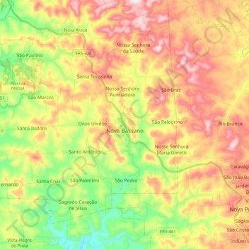
Name: Nova Bassano topographic map, elevation, terrain.
Average elevation: 629 m
Minimum elevation: 408 m
Maximum elevation: 863 m
Make a donation
Other topographic maps
Click on a map to view its topography, its elevation and its terrain.
Estrada Carlos Dreyer
Brazil > Rio Grande do Sul > Metropolitan Region of Porto Alegre > Igrejinha
Average elevation: 622 m
Make a donation
Porto Alegre
Brazil > Rio Grande do Sul > Metropolitan Region of Porto Alegre > Porto Alegre
Porto Alegre has a long coastline on the Guaíba Lake, and its topography is punctuated by 40 hills. In the lake, a vast body of water, a maze of islands facing the city creates an archipelago where a unique ecosystem gives shelter to abundant wildlife. The city area concentrates 28% of the native flora of Rio…
Average elevation: 27 m
Make a donation
Make a donation
Parobé
Brazil > Rio Grande do Sul > Metropolitan Region of Porto Alegre > Parobé > Parobé
Average elevation: 62 m
Make a donation
Pelotas
Brazil > Rio Grande do Sul > Aglomeração Urbana do Sul > Pelotas
As it is situated on a plain near the ocean, the urban area lies on a low elevation, being, on average, 7 meters (23 ft) above sea level. The interior of the municipality is on a plateau called Serras de Sudeste (Southeastern Mountain Ranges). Consequently, the altitude in Pelotas' rural area reaches 429…
Average elevation: 18 m