
Thank you for supporting this site ❤️
Make a donation
Make a donation
Santo Domingo de los Tsachilas topographic map
Click on the map to display elevation.
Thank you for supporting this site ❤️
Make a donation
Make a donation
Santo Domingo de los Tsachilas
Santo Domingo is located approximately 133 km west of Quito at an elevation of 625 m. Santo Domingo lies in the foothills west of the Andes. It is important stopping point on the road from Quito to the Pacific coast. The city also connects other lowland cities like Quevedo, Chone, and Quinindé.
Thank you for supporting this site ❤️
Make a donation
Make a donation
About this map
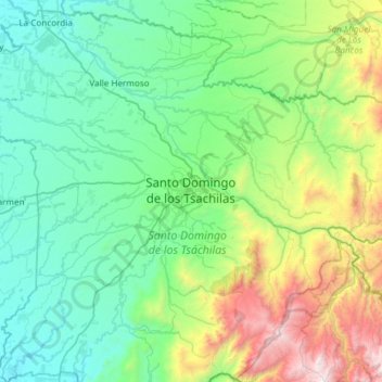
Name: Santo Domingo de los Tsachilas topographic map, elevation, terrain.
Average elevation: 695 m
Minimum elevation: 142 m
Maximum elevation: 2,750 m
Thank you for supporting this site ❤️
Make a donation
Make a donation