
Make a donation
Cairn Gorm topographic map
Click on the map to display elevation.
Make a donation
Cairn Gorm
Cairn Gorm (Scottish Gaelic: An Càrn Gorm) is a mountain in the Scottish Highlands. It is part of the Cairngorms range and wider Grampian Mountains. With a summit elevation of 1,245 m (4,085 ft) above sea level, Cairn Gorm is classed as a Munro and is the sixth-highest mountain in the British Isles. The high, broad domed summit overlooking Strathspey is one of the most readily identifiable mountains from the nearby town and regional centre of Aviemore. Although it shares its name with the Cairngorm mountains, Ben Macdui is the highest mountain in the range.
Make a donation
About this map
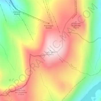
Name: Cairn Gorm topographic map, elevation, terrain.
Location: Cairn Gorm, Highland, Scotland, PH22 1RB, United Kingdom (57.11672 -3.64454 57.11682 -3.64444)
Average elevation: 989 m
Minimum elevation: 694 m
Maximum elevation: 1,244 m
Make a donation
Other topographic maps
Click on a map to view its topography, its elevation and its terrain.
Eilean Donan
United Kingdom > Scotland > Highland > Dornie > Totaig
In 1689, King James VII of the House of Stuart was declared to have to forfeit the throne, and the crown was offered to William of Orange, in the so-called "Glorious Revolution". The revolution also established Presbyterianism in Scotland, although the Highlands generally remained Roman Catholic and loyal to…
Average elevation: 82 m
Make a donation