
Thank you for supporting this site ❤️
Make a donation
Make a donation
Angeac-Champagne topographic map
Click on the map to display elevation.
Thank you for supporting this site ❤️
Make a donation
Make a donation
Angeac-Champagne
The highest point in the commune is at an altitude of 84 m located north-west of Roissac. Another high point of 83 m faces it to the east (topped by an IGN Survey marker). The lowest point is 17 m located in Pas de la Tombe on the south-west edge of the commune near Salles d'Angles. The commune mostly varies in height between 40 and 70 m above sea level.
Thank you for supporting this site ❤️
Make a donation
Make a donation
About this map
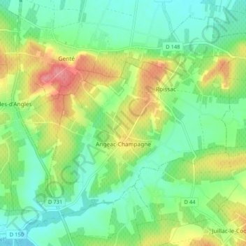
Name: Angeac-Champagne topographic map, elevation, terrain.
Average elevation: 46 m
Minimum elevation: 16 m
Maximum elevation: 99 m
Thank you for supporting this site ❤️
Make a donation
Make a donation
Other topographic maps
Click on a map to view its topography, its elevation and its terrain.