
Salach topographic map
Interactive map
Click on the map to display elevation.
About this map
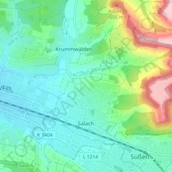
Name: Salach topographic map, elevation, terrain.
Average elevation: 392 m
Minimum elevation: 339 m
Maximum elevation: 545 m
Other topographic maps
Click on a map to view its topography, its elevation and its terrain.
Wanne
Duitsland > Baden-Württemberg > Landkreis Göppingen > Bad Ditzenbach
Wanne, Bad Ditzenbach, Vereinbarte Verwaltungsgemeinschaft der Gemeinde Deggingen, Landkreis Göppingen, Baden-Württemberg, 73342, Duitsland
Average elevation: 660 m