
Thank you for supporting this site ❤️
Make a donation
Make a donation
Sderot topographic map
Click on the map to display elevation.
Thank you for supporting this site ❤️
Make a donation
Make a donation
About this map
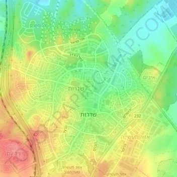
Name: Sderot topographic map, elevation, terrain.
Location: Sderot, Ashkelon Subdistrict, South District, Israel (31.51495 34.57979 31.54756 34.60957)
Average elevation: 89 m
Minimum elevation: 52 m
Maximum elevation: 129 m
Thank you for supporting this site ❤️
Make a donation
Make a donation
Other topographic maps
Click on a map to view its topography, its elevation and its terrain.
Thank you for supporting this site ❤️
Make a donation
Make a donation
Dimona
Dimona is located in the Negev Desert. The city stands at an elevation of around 550–600 metres (1,800–1,970 ft) above sea level.
Average elevation: 559 m
Thank you for supporting this site ❤️
Make a donation
Make a donation