
Thank you for supporting this site ❤️
Make a donation
Make a donation
Isola del Liri topographic map
Click on the map to display elevation.
Thank you for supporting this site ❤️
Make a donation
Make a donation
About this map
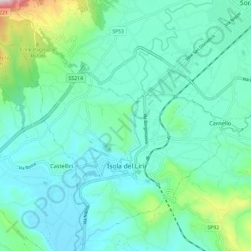
Name: Isola del Liri topographic map, elevation, terrain.
Location: Isola del Liri, Frosinone, Lazio, 03036, Italy (41.65917 13.52097 41.71957 13.60552)
Average elevation: 303 m
Minimum elevation: 198 m
Maximum elevation: 775 m
Thank you for supporting this site ❤️
Make a donation
Make a donation
Other topographic maps
Click on a map to view its topography, its elevation and its terrain.