
Thank you for supporting this site ❤️
Make a donation
Make a donation
Liaocheng topographic map
Click on the map to display elevation.
Thank you for supporting this site ❤️
Make a donation
Make a donation
About this map
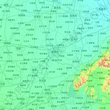
Name: Liaocheng topographic map, elevation, terrain.
Location: Liaocheng, Shandong, 252000, China (35.77288 115.26564 37.03143 116.54417)
Average elevation: 46 m
Minimum elevation: 19 m
Maximum elevation: 494 m
Thank you for supporting this site ❤️
Make a donation
Make a donation
Other topographic maps
Click on a map to view its topography, its elevation and its terrain.