
Make a donation
Prince Patrick Island topographic map
Click on the map to display elevation.
Make a donation
About this map
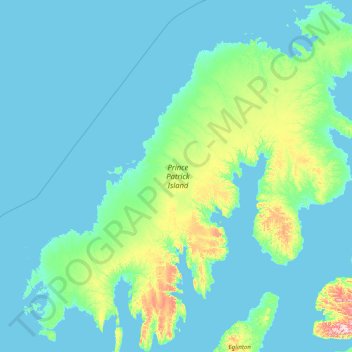
Name: Prince Patrick Island topographic map, elevation, terrain.
Location: Prince Patrick Island, Canada (75.81129 -122.96356 77.56115 -115.34388)
Average elevation: 26 m
Minimum elevation: -3 m
Maximum elevation: 547 m
Make a donation
Other topographic maps
Click on a map to view its topography, its elevation and its terrain.
Toronto
Despite its deep ravines, Toronto is not remarkably hilly, but its elevation does increase steadily away from the lake. Elevation differences range from 76.5 metres (251 ft) above sea level at the Lake Ontario shore to 209 m (686 ft) ASL near the York University grounds in the city's north end at the…
Average elevation: 113 m
London
Canada > Ontario > London > London
London has a humid continental climate (Köppen Dfb), though due to its downwind location relative to Lake Huron and elevation changes across the city, it is virtually on the Dfa/Dfb (hot summer) boundary favouring the former climate zone to the southwest of the confluence of the South and North Thames Rivers,…
Average elevation: 268 m
Make a donation
Banff
Canada > Alberta > Banff > Banff
Banff is a town within Banff National Park in Alberta, Canada. It is located in Alberta's Rockies along the Trans-Canada Highway, approximately 126 km (78 mi) west of Calgary and 58 km (36 mi) east of Lake Louise. At 1,400 to 1,630 m (4,590 to 5,350 ft) above sea level, Banff is the community with the second…
Average elevation: 1,615 m
Guelph
This region of Ontario has cold winters and warm, humid summers, falling into the Köppen climate classification Dfb zone, with moderately high rainfall and snowfall. It is generally a couple of degrees cooler than lower elevation regions on the Great Lakes shorelines, especially so in winter, the exception…
Average elevation: 344 m
Make a donation
Burnaby
Canada > British Columbia > Metro Vancouver Regional District > Burnaby
Burnaby occupies 98.60 square kilometres (38.07 sq mi) and is located at the geographic centre of the Metro Vancouver area and home to the Metro Vancouver regional government in Metrotown. Situated between the city of Vancouver on the west and Port Moody, Coquitlam, and New Westminster on the east, Burnaby is…
Average elevation: 144 m
Whistler
Canada > British Columbia > Squamish-Lillooet Regional District > Whistler Resort Municipality > Whistler
Average elevation: 996 m
Make a donation
Peterborough
Canada > Ontario > Peterborough
Peterborough's topography is largely defined by land formations created by the receding Wisconsian glaciers 10,000–15,000 years ago. The South End and Downtown portions of the City sit on what was the bottom of the glacial Lake Peterborough—part of a glacial spillway created when glacial meltwaters from…
Average elevation: 235 m
Make a donation
Lethbridge
Canada > Alberta > Lethbridge
Its high elevation of 929 m (3,047.9 ft) and close proximity to the Rocky Mountains provides Lethbridge with cooler summers than other locations in the Canadian Prairies. These factors protect the city from strong northwest and southwest winds and contribute to frequent chinook winds during the winter.…
Average elevation: 918 m
Make a donation
Saanich Peninsula
Canada > British Columbia > Capital Regional District > Central Saanich
Average elevation: 49 m
Make a donation
Laurentian Mountains
One of Quebec's official regions is called Laurentides. The mountain range runs through four other regions; Capitale-Nationale, Outaouais, Lanaudière, and Mauricie. The elevation generally ranges from around 500 m (1,640 ft) to 1,000 m (3,280 ft) with Mont Raoul-Blanchard being its highest peak, at 1,166 m…
Average elevation: 348 m
PKOLS (Mount Douglas)
Canada > British Columbia > Capital Regional District > Saanich
Average elevation: 47 m
Dundas
Canada > Ontario > Hamilton > Dundas
Dundas /ˈdʌnˌdæs/ is a community and former town in Hamilton, Ontario, Canada. It is nicknamed the Valley Town because of its topographical location at the bottom of the Niagara Escarpment on the western edge of Lake Ontario. The population has been stable for decades at about twenty thousand, largely…
Average elevation: 171 m
Make a donation
Make a donation
Whistler Village
Canada > British Columbia > Squamish-Lillooet Regional District > Whistler
Average elevation: 775 m
Make a donation
Make a donation
Malakwa
Canada > British Columbia > Columbia-Shuswap Regional District > Area E (Eagle River Valley)
Average elevation: 470 m
Make a donation
Make a donation
Make a donation
Sun Peaks
Canada > British Columbia > Thompson-Nicola Regional District > Sun Peaks Mountain Resort Municipality
Average elevation: 1,490 m
Mount Logan
Due to active tectonic uplifting, Mount Logan is still rising in height (approximately 0.35 mm per year). Before 1992, the exact elevation of Mount Logan was unknown and measurements ranged from 5,959 to 6,050 metres (19,551 to 19,849 ft). In May 1992, a GSC expedition climbed Mount Logan and fixed the current…
Average elevation: 5,292 m
Make a donation
Christina Lake
Canada > British Columbia > Regional District of Kootenay Boundary > Area C (Christina Lake)
Average elevation: 588 m
Make a donation
Make a donation
Canmore
Canada > Alberta > Town of Canmore
Elevation Place opened in April 2013 as Canmore's new recreation facility. Construction of the facility began in 2012 to replace the Canmore Recreation Centre (the community's old facility). The facility offers an 8-lane 25m lap pool, a world class climbing wall developed by Walltopia, two cardio rooms, a…
Average elevation: 1,565 m
Make a donation
Shawnigan Lake
Canada > British Columbia > Cowichan Valley Regional District > Area B (Shawnigan Lake)
Average elevation: 128 m
Make a donation
Make a donation
Make a donation
Esquimalt
Canada > British Columbia > Capital Regional District > Esquimalt > Esquimalt
Average elevation: 14 m
Make a donation
Make a donation
Manitouwabing Lake
Canada > Ontario > Parry Sound District > McKellar Township > McKellar
Average elevation: 249 m
Turtle Mountain Provincial Park
Canada > Manitoba > Municipality of Boissevain – Morton
Turtle Mountain Provincial Park is situated on the Turtle Mountain (plateau), one of a number of significant geographic features located along the Manitoba Escarpment, the Canadian portion of the Pembina Escarpment. It is located in the Southwest Manitoba Uplands Ecoregion, within the Canadian Prairies. The…
Average elevation: 662 m
Make a donation
Make a donation
Gault Nature Reserve
Canada > Quebec > La Vallée-du-Richelieu > Mont-Saint-Hilaire
Average elevation: 189 m
Make a donation