
Make a donation
Gribbell Island topographic map
Click on the map to display elevation.
Make a donation
About this map
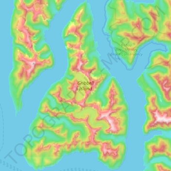
Name: Gribbell Island topographic map, elevation, terrain.
Average elevation: 258 m
Minimum elevation: 0 m
Maximum elevation: 1,145 m
Make a donation
Other topographic maps
Click on a map to view its topography, its elevation and its terrain.
Klemtu
Canada > British Columbia > Regional District of Kitimat-Stikine > Area C (Butedale/Kitlope/Kitsumkalum)
Average elevation: 152 m
Clearwater Lakes
Canada > British Columbia > Regional District of Kitimat-Stikine > Area C (Butedale/Kitlope/Kitsumkalum)
Average elevation: 200 m
Atna Peak
Canada > British Columbia > Regional District of Kitimat-Stikine > Area C (Butedale/Kitlope/Kitsumkalum)
Average elevation: 2,075 m
Deep Creek
Canada > British Columbia > Regional District of Kitimat-Stikine > Area C (Butedale/Kitlope/Kitsumkalum)
Average elevation: 133 m
Make a donation
Kitselas
Canada > British Columbia > Regional District of Kitimat-Stikine > Area C (Butedale/Kitlope/Kitsumkalum) > Kitselas
Average elevation: 226 m
Klemtu
Canada > British Columbia > Regional District of Kitimat-Stikine > Area C (Butedale/Kitlope/Kitsumkalum)
Average elevation: 152 m