
Make a donation
Dawson Creek topographic map
Click on the map to display elevation.
Make a donation
About this map
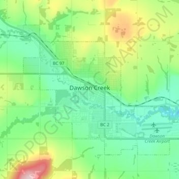
Name: Dawson Creek topographic map, elevation, terrain.
Average elevation: 700 m
Minimum elevation: 626 m
Maximum elevation: 885 m
Make a donation
Other topographic maps
Click on a map to view its topography, its elevation and its terrain.
Submarine Mountain
Canada > British Columbia > Peace River Regional District > Area E (Moberly Lake/Sukunka Valley)
Average elevation: 824 m
Rocky Mountains
Canada > British Columbia > Peace River Regional District > Area D (Kiskatinaw Valley)
Average elevation: 1,458 m
Notch Peak
Canada > British Columbia > Peace River Regional District > Area B (Finlay Valley/Beatton Valley)
Average elevation: 1,602 m
Mica Peak
Canada > British Columbia > Peace River Regional District > Area B (Finlay Valley/Beatton Valley)
Average elevation: 1,740 m
Make a donation
Brooks Falls
Canada > British Columbia > Peace River Regional District > Area E (Moberly Lake/Sukunka Valley)
Average elevation: 1,057 m