
Thank you for supporting this site ❤️
Make a donation
Make a donation
Madre de Dios Island topographic map
Click on the map to display elevation.
Thank you for supporting this site ❤️
Make a donation
Make a donation
About this map
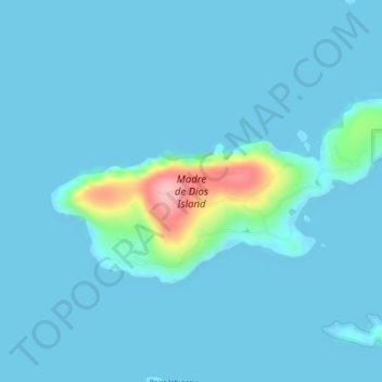
Name: Madre de Dios Island topographic map, elevation, terrain.
Average elevation: 12 m
Minimum elevation: -3 m
Maximum elevation: 137 m
Thank you for supporting this site ❤️
Make a donation
Make a donation
Other topographic maps
Click on a map to view its topography, its elevation and its terrain.
Denali's Fault. Scenic overlook
United States > Alaska > Unorganized Borough > Delta Junction
Average elevation: 379 m
Thank you for supporting this site ❤️
Make a donation
Make a donation
Thank you for supporting this site ❤️
Make a donation
Make a donation
Thank you for supporting this site ❤️
Make a donation
Make a donation