
Thank you for supporting this site ❤️
Make a donation
Make a donation
Willow River topographic map
Click on the map to display elevation.
Thank you for supporting this site ❤️
Make a donation
Make a donation
About this map
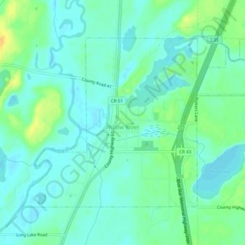
Name: Willow River topographic map, elevation, terrain.
Location: Willow River, Pine County, Minnesota, United States (46.30986 -92.85697 46.33168 -92.81127)
Average elevation: 319 m
Minimum elevation: 310 m
Maximum elevation: 340 m
Thank you for supporting this site ❤️
Make a donation
Make a donation
Other topographic maps
Click on a map to view its topography, its elevation and its terrain.
Devils Lake
United States > Minnesota > Pine County > Pine City > Pine Terrace Mobile Home Park
Average elevation: 295 m
Chengwatana State Forest
United States > Minnesota > Pine County > Rock Creek
Average elevation: 282 m
Thank you for supporting this site ❤️
Make a donation
Make a donation