
Thank you for supporting this site ❤️
Make a donation
Make a donation
Donzdorf topographic map
Click on the map to display elevation.
Thank you for supporting this site ❤️
Make a donation
Make a donation
Donzdorf
Donzdorf is located in the valley of the river Lauter, a tributary of the Fils river, 12 km east of Göppingen, on an elevation between 334 and 749 metres.
Thank you for supporting this site ❤️
Make a donation
Make a donation
About this map
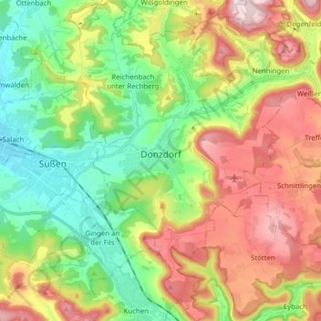
Name: Donzdorf topographic map, elevation, terrain.
Average elevation: 526 m
Minimum elevation: 350 m
Maximum elevation: 781 m
Thank you for supporting this site ❤️
Make a donation
Make a donation
Other topographic maps
Click on a map to view its topography, its elevation and its terrain.