
Thank you for supporting this site ❤️
Make a donation
Make a donation
Presa Grande topographic map
Click on the map to display elevation.
Thank you for supporting this site ❤️
Make a donation
Make a donation
About this map
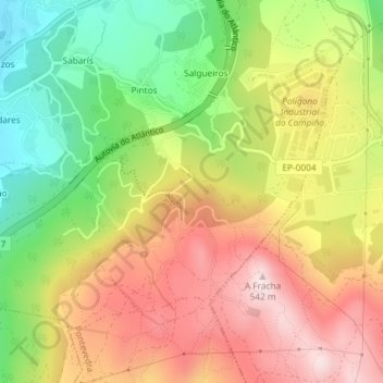
Name: Presa Grande topographic map, elevation, terrain.
Location: Presa Grande, Marcón, Pontevedra, Galicia, 36071, España (42.39203 -8.60696 42.41203 -8.58696)
Average elevation: 313 m
Minimum elevation: 84 m
Maximum elevation: 532 m
Thank you for supporting this site ❤️
Make a donation
Make a donation
Other topographic maps
Click on a map to view its topography, its elevation and its terrain.