
Thank you for supporting this site ❤️
Make a donation
Make a donation
Icklesham topographic map
Click on the map to display elevation.
Thank you for supporting this site ❤️
Make a donation
Make a donation
About this map
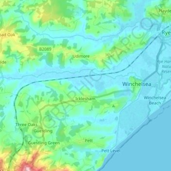
Name: Icklesham topographic map, elevation, terrain.
Location: Icklesham, Rother District, East Sussex, England, United Kingdom (50.90098 0.63598 50.94599 0.77641)
Average elevation: 26 m
Minimum elevation: -2 m
Maximum elevation: 169 m
Thank you for supporting this site ❤️
Make a donation
Make a donation
Other topographic maps
Click on a map to view its topography, its elevation and its terrain.
Bewl Water
United Kingdom > England > East Sussex > Rother District > Ticehurst
Average elevation: 92 m