
Santiago topographic map
Interactive map
Click on the map to display elevation.
About this map
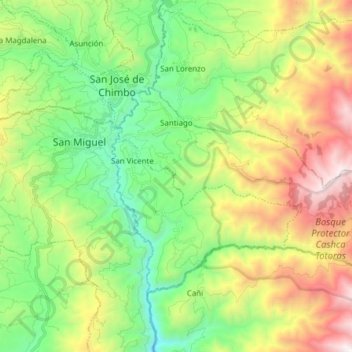
Name: Santiago topographic map, elevation, terrain.
Location: Santiago, San Miguel, Bolívar, Ecuador (-1.76232 -79.02639 -1.68466 -78.87270)
Average elevation: 2,853 m
Minimum elevation: 2,068 m
Maximum elevation: 4,216 m
Other topographic maps
Click on a map to view its topography, its elevation and its terrain.
Guantugpamba
Ecuador > Bolívar > San Miguel > San Pablo de Atenas
Guantugpamba, San Pablo de Atenas, San Miguel, Bolívar, Ecuador
Average elevation: 2,729 m
Guaboloma
Ecuador > Bolívar > San Miguel > San Miguel
Guaboloma, San Miguel, Bolívar, 020301, Ecuador
Average elevation: 2,549 m
Los Ángeles
Ecuador > Bolívar > San Miguel > San Miguel
Los Ángeles, San Miguel, Bolívar, 020302, Ecuador
Average elevation: 2,458 m
San Vicente
Ecuador > Bolívar > San Miguel
San Vicente, San Miguel, Bolívar, Ecuador
Average elevation: 2,629 m
San Jose de las Palmas
Ecuador > Bolívar > San Miguel > San Pablo de Atenas
San Jose de las Palmas, San Pablo de Atenas, San Miguel, Bolívar, Ecuador
Average elevation: 2,699 m
San Pablo de Atenas
Ecuador > Bolívar > San Miguel
San Pablo de Atenas, San Miguel, Bolívar, Ecuador
Average elevation: 2,414 m