
Lac à la Pêche topographic map
Interactive map
Click on the map to display elevation.
About this map
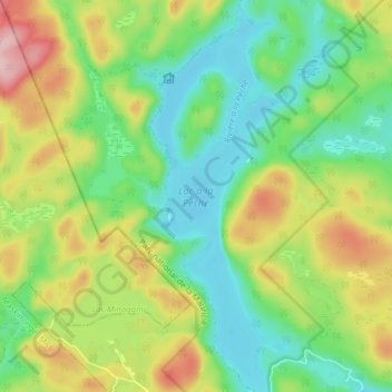
Name: Lac à la Pêche topographic map, elevation, terrain.
Location: Lac à la Pêche, Shawinigan, Mauricie, Quebec, Canada (46.65252 -72.86800 46.70658 -72.84256)
Average elevation: 244 m
Minimum elevation: 170 m
Maximum elevation: 372 m
Other topographic maps
Click on a map to view its topography, its elevation and its terrain.
La Mauricie National Park
Canada > Quebec > Shawinigan
La Mauricie National Park, Shawinigan, Mauricie, Quebec, Canada
Average elevation: 384 m