
Make a donation
Cape Lookout topographic map
Click on the map to display elevation.
Make a donation
About this map
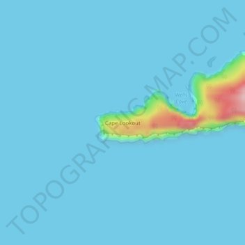
Name: Cape Lookout topographic map, elevation, terrain.
Location: Cape Lookout, Tillamook County, Oregon, United States (45.33873 -124.00417 45.33883 -124.00407)
Average elevation: 11 m
Minimum elevation: 0 m
Maximum elevation: 200 m
Make a donation
Other topographic maps
Click on a map to view its topography, its elevation and its terrain.
Make a donation
Make a donation
Make a donation
Nehalem
United States > Oregon > Tillamook County
Nehalem has an elevation of 11 feet. Lying so close to sea level, the area suffers intermittent floods. A 1996 storm caused particular damage, to local dairy farms. In November 2006, heavy rains caused flooding in Nehalem, resulting in $1 million in damage.
Average elevation: 16 m