
Thank you for supporting this site ❤️
Make a donation
Make a donation
North Canton topographic map
Click on the map to display elevation.
Thank you for supporting this site ❤️
Make a donation
Make a donation
About this map
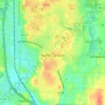
Name: North Canton topographic map, elevation, terrain.
Location: North Canton, Stark County, Ohio, United States (40.85323 -81.42246 40.90082 -81.36327)
Average elevation: 341 m
Minimum elevation: 320 m
Maximum elevation: 370 m
Thank you for supporting this site ❤️
Make a donation
Make a donation
Other topographic maps
Click on a map to view its topography, its elevation and its terrain.