
Thank you for supporting this site ❤️
Make a donation
Make a donation
Nysäter topographic map
Click on the map to display elevation.
Thank you for supporting this site ❤️
Make a donation
Make a donation
About this map
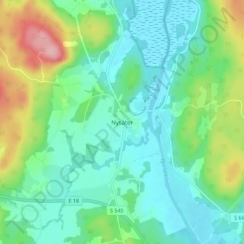
Name: Nysäter topographic map, elevation, terrain.
Location: Nysäter, Säffle kommun, Värmland County, 661 95, Sweden (59.26307 12.75460 59.30307 12.79460)
Average elevation: 84 m
Minimum elevation: 44 m
Maximum elevation: 192 m
Thank you for supporting this site ❤️
Make a donation
Make a donation
Other topographic maps
Click on a map to view its topography, its elevation and its terrain.
Thank you for supporting this site ❤️
Make a donation
Make a donation
Thank you for supporting this site ❤️
Make a donation
Make a donation
Thank you for supporting this site ❤️
Make a donation
Make a donation