
Epauvillers topographic map
Interactive map
Click on the map to display elevation.
About this map
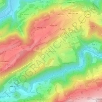
Name: Epauvillers topographic map, elevation, terrain.
Average elevation: 693 m
Minimum elevation: 422 m
Maximum elevation: 998 m
Other topographic maps
Click on a map to view its topography, its elevation and its terrain.
Champ de Lavière
Suisse > Jura > District de Porrentruy > Clos du Doubs > Ocourt
Champ de Lavière, Ocourt, Clos du Doubs, District de Porrentruy, Jura, 2889, Suisse
Average elevation: 619 m
St-Ursanne
Suisse > Jura > District de Porrentruy > Clos du Doubs
St-Ursanne, Clos du Doubs, District de Porrentruy, Jura, 2882, Suisse
Average elevation: 644 m