
Thank you for supporting this site ❤️
Make a donation
Make a donation
Backnang topographic map
Click on the map to display elevation.
Thank you for supporting this site ❤️
Make a donation
Make a donation
Backnang
Before 1930 the title for this position was Stadtschultheiß. In 1930 the title became Bürgermeister (Mayor), and in 1956 with the elevation of Backnang to a "large district town," the title was changed to Oberbürgermeister (Lord Mayor).
Thank you for supporting this site ❤️
Make a donation
Make a donation
About this map
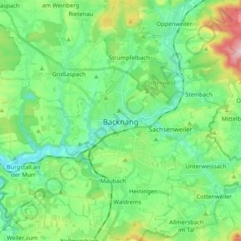
Name: Backnang topographic map, elevation, terrain.
Average elevation: 302 m
Minimum elevation: 216 m
Maximum elevation: 539 m
Thank you for supporting this site ❤️
Make a donation
Make a donation
Other topographic maps
Click on a map to view its topography, its elevation and its terrain.
Kleinhegnach
Germany > Baden-Württemberg > Rems-Murr-Kreis > Waiblingen > Neustadt
Average elevation: 277 m