Geolocate
👉 Easily get elevation data in JSON, GeoTIFF and KML formats using Elevation API
Thank you for supporting this site ❤️
Make a donation

Emerald Pools topographic map

Click on the map to display elevation.

👉 Easily get elevation data in JSON, GeoTIFF and KML formats using Elevation API
Thank you for supporting this site ❤️
Make a donation

About this map

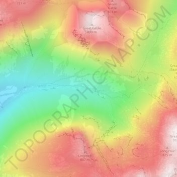
Name: Emerald Pools topographic map, elevation, terrain.

Location: Emerald Pools, Wasdale, Cumberland, England, United Kingdom (54.47219 -3.22040 54.47233 -3.21911)

Average elevation: 523 m

Minimum elevation: 108 m

Maximum elevation: 900 m

Other topographic maps

Click on a map to view its topography, its elevation and its terrain.

Braithwaite

United Kingdom > England > Cumberland

Average elevation: 176 m

Cat Bells

United Kingdom > England > Cumberland > Stair

Average elevation: 182 m

The Green

United Kingdom > England > Cumberland

Average elevation: 64 m

Drumburgh

United Kingdom > England > Cumberland

Average elevation: 6 m

Legburthwaite

United Kingdom > England > Cumberland

Average elevation: 392 m

Bridgefoot

United Kingdom > England > Cumberland

Average elevation: 65 m