
Thank you for supporting this site ❤️
Make a donation
Make a donation
Cusubamba topographic map
Click on the map to display elevation.
Thank you for supporting this site ❤️
Make a donation
Make a donation
About this map
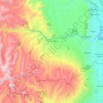
Name: Cusubamba topographic map, elevation, terrain.
Location: Cusubamba, Salcedo, Cotopaxi, Ecuador (-1.15127 -78.84493 -1.03045 -78.63717)
Average elevation: 3,461 m
Minimum elevation: 2,591 m
Maximum elevation: 4,534 m
Thank you for supporting this site ❤️
Make a donation
Make a donation
Other topographic maps
Click on a map to view its topography, its elevation and its terrain.
Thank you for supporting this site ❤️
Make a donation
Make a donation
Laguna de Yambo
Ecuador > Cotopaxi > Salcedo > Patain > San Jose de Curiquingue
Average elevation: 2,664 m
Thank you for supporting this site ❤️
Make a donation
Make a donation