
Thank you for supporting this site ❤️
Make a donation
Make a donation
Clymer topographic map
Click on the map to display elevation.
Thank you for supporting this site ❤️
Make a donation
Make a donation
About this map
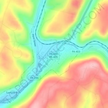
Name: Clymer topographic map, elevation, terrain.
Location: Clymer, Indiana County, Pennsylvania, United States (40.65794 -79.02810 40.68249 -79.00130)
Average elevation: 443 m
Minimum elevation: 367 m
Maximum elevation: 519 m
Thank you for supporting this site ❤️
Make a donation
Make a donation
Other topographic maps
Click on a map to view its topography, its elevation and its terrain.
Robinson
United States > Pennsylvania > Indiana County > West Wheatfield Township
Average elevation: 397 m
Thank you for supporting this site ❤️
Make a donation
Make a donation
Thank you for supporting this site ❤️
Make a donation
Make a donation