
Thank you for supporting this site ❤️
Make a donation
Make a donation
City of Oneida topographic map
Click on the map to display elevation.
Thank you for supporting this site ❤️
Make a donation
Make a donation
About this map
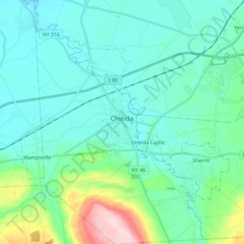
Name: City of Oneida topographic map, elevation, terrain.
Average elevation: 165 m
Minimum elevation: 115 m
Maximum elevation: 398 m
Thank you for supporting this site ❤️
Make a donation
Make a donation
Other topographic maps
Click on a map to view its topography, its elevation and its terrain.
North Chittenango
United States > New York > Madison County > Town of Sullivan
Average elevation: 127 m
Thank you for supporting this site ❤️
Make a donation
Make a donation
Five Chimneys Corner
United States > New York > Madison County > Town of Stockbridge
Average elevation: 225 m