
Thank you for supporting this site ❤️
Make a donation
Make a donation
Malthi topographic map
Click on the map to display elevation.
Thank you for supporting this site ❤️
Make a donation
Make a donation
About this map
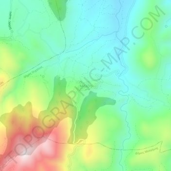
Name: Malthi topographic map, elevation, terrain.
Average elevation: 390 m
Minimum elevation: 165 m
Maximum elevation: 862 m
Thank you for supporting this site ❤️
Make a donation
Make a donation
Other topographic maps
Click on a map to view its topography, its elevation and its terrain.
Municipality of Kalamata
Greece > Peloponnese, Western Greece and the Ionian > Messenia Regional Unit
Average elevation: 490 m
Sphacteria
Greece > Peloponnese, Western Greece and the Ionian > Messenia Regional Unit > Pylos
Average elevation: 6 m