
Thank you for supporting this site ❤️
Make a donation
Make a donation
Vosburg topographic map
Click on the map to display elevation.
Thank you for supporting this site ❤️
Make a donation
Make a donation
About this map
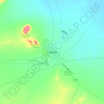
Name: Vosburg topographic map, elevation, terrain.
Average elevation: 1,137 m
Minimum elevation: 1,106 m
Maximum elevation: 1,238 m
Thank you for supporting this site ❤️
Make a donation
Make a donation
Other topographic maps
Click on a map to view its topography, its elevation and its terrain.
Kareeberg Ward 4
South Africa > Northern Cape > Pixley ka Seme District Municipality > Kareeberg Local Municipality
Average elevation: 1,095 m