
Thank you for supporting this site ❤️
Make a donation
Make a donation
Haltern am See topographic map
Click on the map to display elevation.
Thank you for supporting this site ❤️
Make a donation
Make a donation
About this map
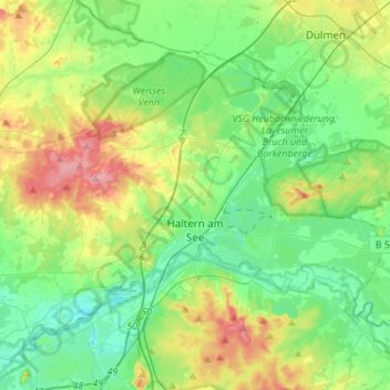
Name: Haltern am See topographic map, elevation, terrain.
Average elevation: 63 m
Minimum elevation: 25 m
Maximum elevation: 151 m
Thank you for supporting this site ❤️
Make a donation
Make a donation
Other topographic maps
Click on a map to view its topography, its elevation and its terrain.
Sythen
Germany > North Rhine-Westphalia > Kreis Recklinghausen > Haltern am See
Average elevation: 54 m
Holtwick
Germany > North Rhine-Westphalia > Kreis Recklinghausen > Haltern am See
Average elevation: 89 m
Sythen
Germany > North Rhine-Westphalia > Kreis Recklinghausen > Haltern am See
Average elevation: 54 m
Thank you for supporting this site ❤️
Make a donation
Make a donation