
Thank you for supporting this site ❤️
Make a donation
Make a donation
Bancak topographic map
Click on the map to display elevation.
Thank you for supporting this site ❤️
Make a donation
Make a donation
About this map
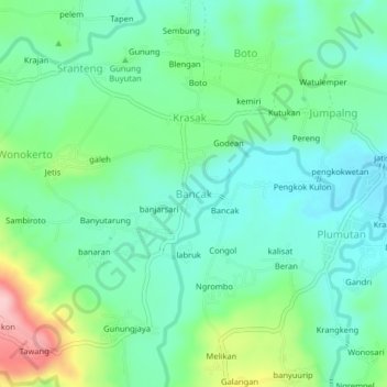
Name: Bancak topographic map, elevation, terrain.
Location: Bancak, Semarang, Central Java, Java, Indonesia (-7.26393 110.57271 -7.22393 110.61271)
Average elevation: 134 m
Minimum elevation: 79 m
Maximum elevation: 280 m
Thank you for supporting this site ❤️
Make a donation
Make a donation
Other topographic maps
Click on a map to view its topography, its elevation and its terrain.