
Make a donation
Slatington topographic map
Click on the map to display elevation.
Make a donation
Slatington
According to the U.S. Census Bureau, the borough has a total area of 1.4 square miles (3.6 km2), of which 1.3 square miles (3.4 km2) are land and 0.1 square miles (0.26 km2), or 4.35%, are water. Slatington's elevation is 380 feet (120 m) above sea level at the center of town. The elevation varies from 345 feet (105 m) at the Lehigh River on the east side of town to 742 feet (226 m) atop a hill south of South Street, west of Pennsylvania Route 873.
Make a donation
About this map
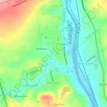
Name: Slatington topographic map, elevation, terrain.
Location: Slatington, Lehigh County, Pennsylvania, United States (40.74099 -75.62456 40.77363 -75.59797)
Average elevation: 153 m
Minimum elevation: 104 m
Maximum elevation: 244 m
Make a donation
Other topographic maps
Click on a map to view its topography, its elevation and its terrain.
East Texas
United States > Pennsylvania > Lehigh County > Lower Macungie Township
Average elevation: 126 m
Hillside
United States > Pennsylvania > Lehigh County > South Whitehall Township
Average elevation: 152 m
Fogelsville
United States > Pennsylvania > Lehigh County > Upper Macungie Township
Average elevation: 155 m
North Coplay
United States > Pennsylvania > Lehigh County > Whitehall > Cementon
Average elevation: 116 m
Make a donation
Leather Corner Post
United States > Pennsylvania > Lehigh County > Lowhill Township
Average elevation: 178 m
Centreville
United States > Pennsylvania > Lehigh County > Lower Macungie Township
Average elevation: 144 m
South Mountain
United States > Pennsylvania > Lehigh County > Upper Saucon
Unlike Blue Mountain to its north, South Mountain does not follow a straight geographic line. The mountain ranges in elevation between 500 and 1,300 feet (150 and 400 m) above sea level. The ridge is made of metamorphic rocks and gneiss, which date to the Precambrian era and range from about 570 million to…
Average elevation: 153 m
Make a donation
Limeport
United States > Pennsylvania > Lehigh County > Lower Milford Township
Average elevation: 203 m
Orefield
United States > Pennsylvania > Lehigh County > North Whitehall Township
Average elevation: 141 m
Wescosville
United States > Pennsylvania > Lehigh County > Lower Macungie Township
Average elevation: 128 m
Make a donation
Fogelsville
United States > Pennsylvania > Lehigh County > Upper Macungie Township
Average elevation: 155 m
Vera Cruz Station
United States > Pennsylvania > Lehigh County > Upper Milford Township
Average elevation: 199 m
South Mountain
United States > Pennsylvania > Lehigh County > Upper Saucon
Unlike Blue Mountain to its north, South Mountain does not follow a straight geographic line. The mountain ranges in elevation between 500 and 1,300 feet (150 and 400 m) above sea level. The ridge is made of metamorphic rocks and gneiss, which date to the Precambrian era and range from about 570 million to…
Average elevation: 153 m
Make a donation
Trexlertown
United States > Pennsylvania > Lehigh County > Upper Macungie Township
Trexlertown is located southwest of the center of Lehigh County along the southeastern edge of Upper Macungie Township at an altitude of 397 feet (121 m). It is bordered to the southwest by Breinigsville and to the southeast by Lower Macungie Township. U.S. Route 222 forms the northern edge of the community;…
Average elevation: 127 m
Saegersville
United States > Pennsylvania > Lehigh County > Heidelberg Township
Average elevation: 208 m
North Fogelsville
United States > Pennsylvania > Lehigh County > Upper Macungie Township > Fogelsville
Average elevation: 165 m
Kernsville
United States > Pennsylvania > Lehigh County > North Whitehall Township
Average elevation: 147 m
Make a donation
Ironton
United States > Pennsylvania > Lehigh County > North Whitehall Township
Average elevation: 158 m
Leather Corner Post
United States > Pennsylvania > Lehigh County > Lowhill Township
Average elevation: 178 m
Orefield
United States > Pennsylvania > Lehigh County > North Whitehall Township
Average elevation: 141 m
Make a donation
Weilersville
United States > Pennsylvania > Lehigh County > Lower Macungie Township
Average elevation: 126 m
Jordan Valley
United States > Pennsylvania > Lehigh County > Heidelberg Township
Average elevation: 213 m
Cherry Hill
United States > Pennsylvania > Lehigh County > Upper Macungie Township
Average elevation: 146 m
Weidasville
United States > Pennsylvania > Lehigh County > Lowhill Township > Weidasville
Average elevation: 170 m
Make a donation
Crackersport
United States > Pennsylvania > Lehigh County > South Whitehall Township
Average elevation: 138 m
Ormrod
United States > Pennsylvania > Lehigh County > North Whitehall Township
Average elevation: 148 m