
Thank you for supporting this site ❤️
Make a donation
Make a donation
El Ciego topographic map
Click on the map to display elevation.
Thank you for supporting this site ❤️
Make a donation
Make a donation
About this map
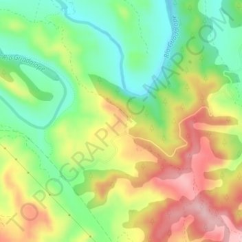
Name: El Ciego topographic map, elevation, terrain.
Location: El Ciego, Alcañiz, Bajo Aragón, Teruel, Aragón, 44600, España (41.05290 -0.09244 41.07290 -0.07244)
Average elevation: 330 m
Minimum elevation: 244 m
Maximum elevation: 435 m
Thank you for supporting this site ❤️
Make a donation
Make a donation
Other topographic maps
Click on a map to view its topography, its elevation and its terrain.
Salada de la Jabonera de las Torrazas
España > Aragón > Bajo Aragón > Alcañiz
Average elevation: 354 m