Geolocate

Sunderbani topographic map

Click on the map to display elevation.

About this map

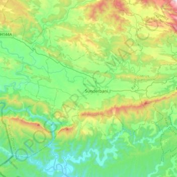
Name: Sunderbani topographic map, elevation, terrain.

Location: Sunderbani, Rajouri District, Jammu and Kashmir, 185153, India (32.95066 74.31951 33.15618 74.63362)

Average elevation: 646 m

Minimum elevation: 281 m

Maximum elevation: 1,620 m

Other topographic maps

Click on a map to view its topography, its elevation and its terrain.

Srinagar

India > Jammu and Kashmir > Srinagar (South)

Under the Köppen climate classification, Srinagar has a four-season humid subtropical climate (Cfa) with hot summers and cool winters. The valley is surrounded by the Himalayas on all sides. Due to influence from Himalayan rain shadow and western disturbances, Srinagar has year-round precipitation; the spring…

Average elevation: 1,805 m

Pambai

India > Jammu and Kashmir > Kulgam

Average elevation: 1,856 m

Pariwan

India > Jammu and Kashmir > Kulgam

Average elevation: 1,885 m

Madargom

India > Jammu and Kashmir > Kulgam

Average elevation: 1,824 m

Kathua

India > Jammu and Kashmir

Average elevation: 1,162 m

Ujroo

India > Jammu and Kashmir > Dooru tehsil

Average elevation: 1,797 m

Kishtwar

India > Jammu and Kashmir > Kishtwar

Average elevation: 1,935 m

Bandipora

India > Jammu and Kashmir > Bandipora

Average elevation: 1,743 m

Devsar

India > Jammu and Kashmir > Devsar

Average elevation: 1,710 m

Sopore

India > Jammu and Kashmir > Sopore

Average elevation: 1,583 m

Nowpora

India > Jammu and Kashmir > Shopian

Average elevation: 1,727 m

Jammu and Kashmir

India > Jammu and Kashmir

Average elevation: 3,848 m

Pir Panjal Range

India > Jammu and Kashmir > Mandi tehsil

Average elevation: 3,285 m

Handwara

India > Jammu and Kashmir > Handwara tehsil

Handwara is located at 34°24′N 74°17′E / 34.40°N 74.28°E / 34.40; 74.28 at an average elevation of 1,582 metres (5,190 feet) above sea level.

Average elevation: 1,638 m

Kashmir Valley

India > Jammu and Kashmir > Srīnagar > Shalteng

The Kashmir Valley lies between latitude 33° and 35°N, and longitude 73° and 76°E. The valley is 100 km (62 mi) wide and covers 15,520.3 km2 (5,992.4 sq mi) in area. It is bounded by sub-ranges of the Western Himalayas: the Great Himalayas bound it in the northeast and separate it from the Tibetan Plateau,…

Average elevation: 1,585 m

Ratnipora

India > Jammu and Kashmir > Pulwama tehsil

Average elevation: 1,592 m

Lamimarg

India > Jammu and Kashmir > Damhal Hanjipora > Nasnur

Average elevation: 2,163 m

Kishtwar

India > Jammu and Kashmir > Kishtwar

Average elevation: 1,935 m

Beerwah

India > Jammu and Kashmir > Beerwah tehsil

Average elevation: 1,799 m

MAGAM

India > Jammu and Kashmir > Tangmarg

Average elevation: 1,592 m

bagila

India > Jammu and Kashmir > Sunderbani > Sunderbani

Average elevation: 588 m

Harwan

India > Jammu and Kashmir > Sopore

Average elevation: 1,830 m

Harwan Garden

India > Jammu and Kashmir > Srinagar (North)

Average elevation: 1,739 m

Kalakote

India > Jammu and Kashmir > Kalakote

Average elevation: 833 m

Batote

India > Jammu and Kashmir > Ramban

Average elevation: 1,592 m

Awantipora

India > Jammu and Kashmir > Awantipora

Average elevation: 1,698 m

Dharspun

India > Jammu and Kashmir > Banihal > Banihal

Average elevation: 1,908 m

Wussan

India > Jammu and Kashmir > Kangan

Average elevation: 1,893 m

Bathnoor

India > Jammu and Kashmir > Tral

Average elevation: 2,132 m

Ranger

India > Jammu and Kashmir > Chadoora tehsil

Average elevation: 1,670 m

Sogam

India > Jammu and Kashmir > Chadoora tehsil

Average elevation: 1,703 m

Mirhama

India > Jammu and Kashmir > Kulgam

Average elevation: 1,805 m

Teetwal

India > Jammu and Kashmir > Karnah

Average elevation: 1,448 m

Gurez Valley

India > Jammu and Kashmir > Kanzalwan

Average elevation: 2,567 m

Jammu

India > Jammu and Kashmir > Jammu

Jammu is located at 32°44′N 74°52′E / 32.73°N 74.87°E / 32.73; 74.87. It has an average elevation of 300 m (980 ft). Jammu city lies at uneven ridges of low heights at the Shivalik hills. It is surrounded by the Shivalik range to the north, east, and southeast while the Trikuta Range surrounds…

Average elevation: 367 m

Srinagar

India > Jammu and Kashmir > Srinagar (South)

Under the Köppen climate classification, Srinagar has a four-season humid subtropical climate (Cfa) with hot summers and cool winters. The valley is surrounded by the Himalayas on all sides. Due to influence from Himalayan rain shadow and western disturbances, Srinagar has year-round precipitation; the spring…

Average elevation: 1,805 m

Jammu

India > Jammu and Kashmir > Jammu

Jammu is located at 32°44′N 74°52′E / 32.73°N 74.87°E / 32.73; 74.87. It has an average elevation of 300 m (980 ft). Jammu city lies at uneven ridges of low heights at the Shivalik hills. It is surrounded by the Shivalik range to the north, east, and southeast while the Trikuta Range surrounds…

Average elevation: 367 m

Ramban

India > Jammu and Kashmir > Ramban

Ramban district has an average elevation of 747 metres (3792 feet). The boundary lines of Ramban district have come to be drawn from Patnitop on its south, Assar on its east, Gool on its west and Banihal on its north. Ramban district comprises seven Tehsils, namely Banihal, Khari, Pogal Paristan, Ramban,…

Average elevation: 1,332 m

Basohli

India > Jammu and Kashmir > Bashohli

Average elevation: 570 m

Gulabgarh

India > Jammu and Kashmir > Atholi (Paddar)

Average elevation: 2,225 m

Latti Dhuna

India > Jammu and Kashmir > Ramnagar

Average elevation: 1,855 m

Dhaggar

India > Jammu and Kashmir > Bani

Average elevation: 2,169 m

Langate

India > Jammu and Kashmir > Handwara tehsil

Average elevation: 1,629 m

Susa

India > Jammu and Kashmir > Ramban

Average elevation: 1,628 m

Khag

India > Jammu and Kashmir > Beerwah tehsil

Average elevation: 1,990 m

Tangdhar

India > Jammu and Kashmir > Karnah

Average elevation: 2,112 m

Sarwal

India > Jammu and Kashmir > Chhatroo

Average elevation: 4,075 m

Tirigom

India > Jammu and Kashmir > Kulgam

Average elevation: 1,716 m

Surankote

India > Jammu and Kashmir > Surankote tehsil

Average elevation: 1,508 m

Uttarsu

India > Jammu and Kashmir > Shangus tehsil

Average elevation: 1,781 m

Baramulla

India > Jammu and Kashmir > Baramulla

Baramulla is located at 34.2° N 74.34° E. It has an average elevation of 1,593 meters (5,226 feet).

Average elevation: 1,969 m

Batpora

India > Jammu and Kashmir > Chadoora tehsil

Average elevation: 1,616 m

R S Pura

India > Jammu and Kashmir > Ranbir Singh Pora

Average elevation: 272 m

Kulgam

India > Jammu and Kashmir > Kulgam

Average elevation: 1,732 m

Tham

India > Jammu and Kashmir > Atholi (Paddar)

Average elevation: 2,870 m

Khrew

India > Jammu and Kashmir > Pampore

Khrew is located at 34°01′12″N 74°59′24″E / 34.020°N 74.99°E / 34.020; 74.99. It has an average elevation of 1,607 metres (5,272 feet) and is located in the Kashmir valley. The area starts from Babapora to Seer Bagh and from Bathen to Androosa. Also, the foot region is extended to Ladhoo,…

Average elevation: 1,788 m

Jyothipuram

India > Jammu and Kashmir > Reasi

Average elevation: 801 m

Patnitop

India > Jammu and Kashmir > Ramban

Average elevation: 1,793 m

Wahipora

India > Jammu and Kashmir > Tangmarg

Average elevation: 1,998 m

Vaishno Devi

India > Jammu and Kashmir > Reasi

Average elevation: 1,706 m

Kokernag

India > Jammu and Kashmir > Kokernag Tehsil

Average elevation: 2,084 m

Panjera

India > Jammu and Kashmir > Billawar

Average elevation: 1,534 m

Ramnagri

India > Jammu and Kashmir > Shopian

Average elevation: 2,087 m

Gulmarg

India > Jammu and Kashmir > Tangmarg

Gulmarg (also known as Gulmarag, lit. 'meadow of flowers' in Kashmiri) is a hill station and a notified area committee in Baramulla district of the Indian union territory of Jammu and Kashmir. It is located in the Indian administered Kashmir, close to the Line of Control that serves as the de facto border…

Average elevation: 2,590 m

TRC Park

India > Jammu and Kashmir > Srinagar (South) > Srinagar

Average elevation: 1,594 m

Bandipora

India > Jammu and Kashmir > Bandipora

Average elevation: 1,743 m

Awantipora

India > Jammu and Kashmir > Awantipora

Average elevation: 1,698 m

yanar

India > Jammu and Kashmir > Pahalgam

Average elevation: 2,041 m

Handwara

India > Jammu and Kashmir > Handwara tehsil

Handwara is located at 34°24′N 74°17′E / 34.40°N 74.28°E / 34.40; 74.28 at an average elevation of 1,582 metres (5,190 feet) above sea level. The region boasts breathtaking natural beauty, with the Pohru River (locally called 'Talri river')—a tributary of the Jhelum—flowing through the town.

Average elevation: 1,638 m

Sonamarg

India > Jammu and Kashmir > Kangan

The hill station is situated in the Kashmir Valley, at an altitude of 2,730 metres (8,960 ft) Combined with the alpine meadows that bloom in the summer as well as rivers and lakes stocked with fish, Sonamarg is a notable tourist destination in Jammu and Kashmir.

Average elevation: 3,068 m

kursari

India > Jammu and Kashmir > Bhaderwah

Average elevation: 1,719 m

Kanthan

India > Jammu and Kashmir > Gool-Gulabgarh

Average elevation: 820 m

Chasana

India > Jammu and Kashmir > Gool-Gulabgarh

Average elevation: 1,368 m

Baggan

India > Jammu and Kashmir > Billawar

Average elevation: 1,268 m

Panchari

India > Jammu and Kashmir > Udhampur > Udhampur

Average elevation: 1,340 m

Basantgarh

India > Jammu and Kashmir > Ramnagar

Average elevation: 2,038 m

Kishtwar

India > Jammu and Kashmir > Kishtwar

Average elevation: 1,935 m

maloti

India > Jammu and Kashmir > Bhaderwah

Average elevation: 1,525 m

Udhampur

India > Jammu and Kashmir > Udhampur

The district of Udhampur is located in the Shivalik range of Himalayas and the terrain is mostly mountainous. The upper reaches of the district experience snowfall in the winter season like Panchari Landhar, ladha dhar, Patnitop, Sudhmahadev, Latti, Dudu, and Basantgarh. The city itself is in a relatively…

Average elevation: 1,078 m

Miraun

India > Jammu and Kashmir > Gandoh

Average elevation: 2,604 m

Shopian

India > Jammu and Kashmir > Shopian

Average elevation: 2,051 m

Poonch

India > Jammu and Kashmir > Haveli tehsil

Average elevation: 1,205 m

Akhnoor

India > Jammu and Kashmir > Akhnoor

Average elevation: 357 m

Seer Hamdan

India > Jammu and Kashmir > Anantnag

Average elevation: 1,769 m

Hajin

India > Jammu and Kashmir > Sonawari

Average elevation: 1,582 m

Sumbal

India > Jammu and Kashmir > Sonawari

Average elevation: 1,594 m

Yaripora

India > Jammu and Kashmir > Kulgam

Average elevation: 1,672 m

Srinagar

India > Jammu and Kashmir > Srīnagar

Average elevation: 1,598 m

Kullan

India > Jammu and Kashmir > Kangan

Average elevation: 2,529 m

Chunt Valiwar

India > Jammu and Kashmir > Lar

Average elevation: 2,125 m

Rangreth

India > Jammu and Kashmir > Badgam tehsil

Average elevation: 1,612 m

Nowshera

India > Jammu and Kashmir > Nowshehra Tehsil

Given its spatial and demographic extent, Nowshera has been given the status of a Sub-District. It is a beautiful place with a number of tourist attractions including the fort of Mangla Devi, holy cave temple of Mangla Mata, Central Gurudwara of Sikhs in Nonial, Qila Darhal and other Dargahs and temples. The…

Average elevation: 668 m

Asnoor

India > Jammu and Kashmir > Damhal Hanjipora

Average elevation: 2,193 m

Chadoora

India > Jammu and Kashmir > Chadoora tehsil

Average elevation: 1,664 m

Manjini

India > Jammu and Kashmir > Gandoh

Average elevation: 3,330 m

Salal

India > Jammu and Kashmir > Reasi

Average elevation: 664 m

nari

India > Jammu and Kashmir > Gool-Gulabgarh > richbangla

Average elevation: 2,649 m