
Bacnotan topographic map
Click on the map to display elevation.
Bacnotan
The topography of the town is characterized by hilly and mountainous terrain rising gradually eastward. The western side of Bacnotan is defined by a long stretch of black sand beaches facing the South China Sea, indicative of the area's abundant magnetite deposits. Certain parts of the coastline also feature pebble and limestone formations. These beaches, which span approximately 16 kilometers, are well-suited for various recreational activities such as fishing, boating, swimming, snorkeling, diving, and surfing. While San Juan is widely known as a popular destination for serious surfers, the waves in Bacnotan's Quirino area have also gained recognition for being excellent for surfing.
About this map
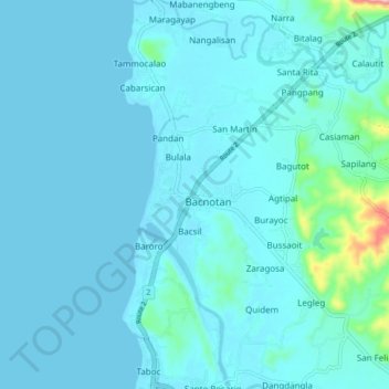
Name: Bacnotan topographic map, elevation, terrain.
Location: Bacnotan, La Union, Ilocos Region, 2525, Philippines (16.68026 120.31259 16.76026 120.39259)
Average elevation: 21 m
Minimum elevation: -1 m
Maximum elevation: 207 m
Other topographic maps
Click on a map to view its topography, its elevation and its terrain.
Rosario
The topography of Rosario is characterized by a valley with mountainous terrain, predominantly shaped by the sharply sloping mountains of the Cordillera Central range, which runs parallel to the coast of the South China Sea. To the west, the land features narrow plains and valleys, interspersed with shallow…
Average elevation: 337 m
Tubao
Rural topography is seventy percent (70%) alluvial plains and thirty percent (30%) uplands. Highest portion is located in Barangay Rizal, which is more than 500 metres (1,600 ft) above sea level along the foothill of Cordillera Central. Flat lands are found in the middle portion of the town, in between its…
Average elevation: 84 m
Agoo-Damortis Protected Landscape and Seascape
Philippines > La Union > Santo Tomas
Average elevation: 9 m
Rosario
The topography of Rosario is characterized by a valley with mountainous terrain, predominantly shaped by the sharply sloping mountains of the Cordillera Central range, which runs parallel to the coast of the South China Sea. To the west, the land features narrow plains and valleys, interspersed with shallow…
Average elevation: 337 m
Aringay
Aringay is a coastal municipality in La Union with a land area of 84.54 square kilometers (32.64 square miles), comprising 5.64% of La Union's total area. The municipality's topography features hilly and mountainous terrains that rise gradually eastward from the coastal plains. Situated at the foothills of the…
Average elevation: 90 m
San Fernando
The city's topography is characterized by predominantly hilly terrain that gradually rises eastward from the coastal plains. It is traversed by several rivers and creeks, including the Carlatan and Catbangen rivers. The landscape also features scrublands, grasslands, wetlands, and is in proximity to seven…
Average elevation: 68 m
Aringay
Aringay is a coastal municipality in La Union with a land area of 84.54 square kilometers (32.64 square miles), comprising 5.64% of La Union's total area. The municipality's topography features hilly and mountainous terrains that rise gradually eastward from the coastal plains. Situated at the foothills of the…
Average elevation: 90 m
Agoo
The town's topography is characterized by hilly and mountainous terrain that rises gradually eastward from the coastal plains. Its landscape is also marked by wetlands, scrublands, and grasslands. Mount Katayagan, the highest peak in the town, provides a watershed that supplies water for irrigation and…
Average elevation: 57 m
Pugo
The town's topography is predominantly hilly and mountainous, as it is nestled at the foothills of the Mount Santo Tomas (Cordillera Central) a stratovolcano. Lush and peaceful forests cover much of the area, with the terrain rising gradually eastward. Rural areas in the town are characterized by alluvial…
Average elevation: 328 m
Tubao
Rural topography is seventy percent (70%) alluvial plains and thirty percent (30%) uplands. Highest portion is located in Barangay Rizal, which is more than 500 metres (1,600 ft) above sea level along the foothill of Cordillera Central. Flat lands are found in the middle portion of the town, in between its…
Average elevation: 84 m
Rosario
The topography of Rosario is characterized by a valley with mountainous terrain, predominantly shaped by the sharply sloping mountains of the Cordillera Central range, which runs parallel to the coast of the South China Sea. To the west, the land features narrow plains and valleys, interspersed with shallow…
Average elevation: 337 m
Agoo
The town’s topography is characterized by hilly and mountainous terrain that rises gradually eastward from the coastal plains. Its landscape is also marked by wetlands, scrublands, and grasslands. Mount Katayagan, the highest peak in the town, provides a watershed that supplies water for irrigation and…
Average elevation: 57 m